

Brief Introduction
SurDex 6.0 is a robust engineering surveying application software designed to streamline high-precision geospatial data acquisition and stakeout. Developed with extensive input from industry professionals and built on an intuitive Android platform, SurDex 6.0 integrates essential surveying workflows for professional surveyors, civil engineers, and construction personnel, mainly includes the following applications:
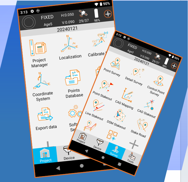
Setting-up & Operate GNSS Receivers
High-precision centimeter level position surveying
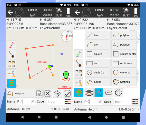
Point, line, and road stakeout
CAD mapping and stakeout

Main Features:
Multi-language Switching Options
Support multi-language interface switching to meet the needs of international projects.

Various data formats for Output & Import
DXF, SHP, DWG and KML file import/export.
Automated CAD drawing generation from point measurements using feature codes for efficient multi-layer data capture.
Global Coordinate System Templates
Built-in global coordinate system templates, easy to select your local coordinates system Parameters directly from the predefined list.
Advantages:


CAD Auto Drawing & Mapping
Intelligent Stakeout System
Intelligent Stakeout System

Intelligent Stakeout System
Main Applications
SurDex 6.0 is designed for a wide array of GIS Surveying & Mapping applications, mainly includes:
-
Connect to high-precision GNSS devices for various operations, including:
o Communication and device settings
o Rover, Base, and Static surveying
o Device information and status monitoring
o Satellite information and positioning data visualization
-
Efficient and accurate collection of geospatial data for GIS Surveying & Mapping applications.
-
· Stakeout, deviation correction, and as-built surveys for various construction projects.
-
Design and stakeout for road projects, including complex curve and slope management.
-
Boundary surveys, topographic surveys, and cadastral mapping.


Setting-up & Operate GNSS Receivers
Supports multiple operational modes
Base station Setup
Rover / Ntrip CORS Rover Setup
Static GPS Receiver Settings
Flexible solutions compatible with variety of GNSS Receivers Brands & Models.