CORS Station GNSS Receiver
Fast response within 24 hours
Key Advantages

All-Constellation Tracking
1408 satellite channels
supports full GNSS tracking

Rugged Design
IP 68 design. Pass salt spray and mold tests
Rich Communications
Support 4G, LTE, Bluetooth, WiFi and WLAN.

Main Features

High Performance Chip
Adopt Lyra|| bassband chip;
fully compatible with Beidou-3;
support multi-constellation GNSS.
Outstanding System
Linux OS: stable, open-source, low-power consumption;
Multiple serial ports, support Ntrip, TCP/UDP, and FTP.

Rubust Power
High-capacity lithium battery;
Over 15 hours of continuous operation.
| GNSS | |
| Satellites Tracking |
GPS: L1C/A, L2P (Y), L2C, L5 BDS: B1I, B2I, B3I, B1C, B2a, B2b GLONASS: L1, L2 GALILEO: E1, E5a, E5b, E6 QZSS: L1, L2, L5, L6 SBAS: L1, L5 L-Band: B2b PPP (Only for the Asian-Pacific region) |
|---|---|
| Channels | 1408 |
| Signal Reacquisition | < 1 second |
| Cold Start | < 60 seconds |
| Warm Start | < 30 seconds |
| Hot Start | < 10 seconds |
| Initialization Reliability | > 99.9% |
| Update Rate | 20 Hz |
| Operation System | Linux + A8 |
| Internal Memory | 32G |
| Communication | |
| Bluetooth | BT5.0 + EDR, compatible with BLE |
| Wi-Fi | 802.11 b/g/n |
| Ethernet | Support |
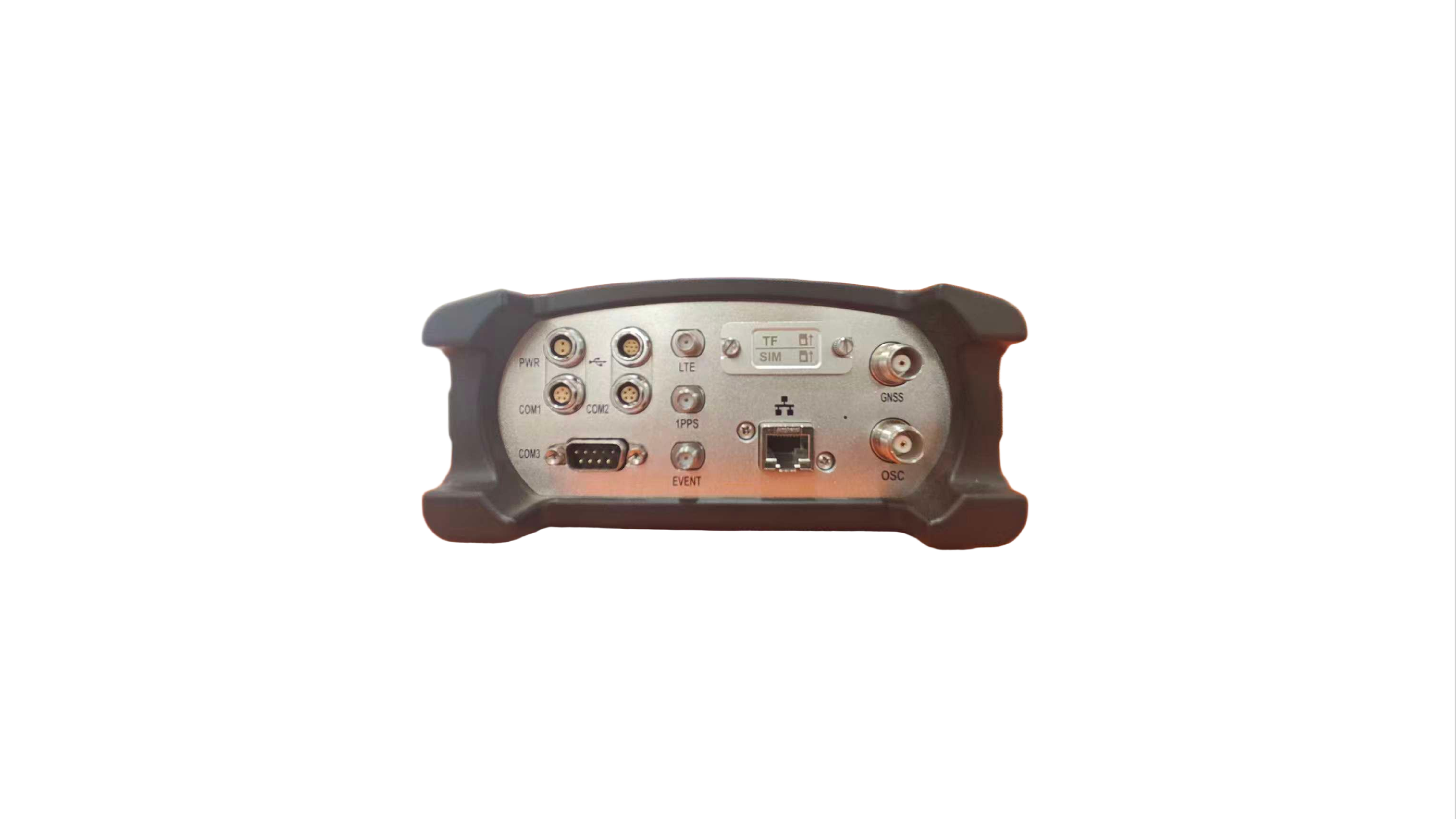
| Port |
2-pin, DC in 7-pin USB OTG, host / client 5-pin RS232 5-pin RS232/RS485 DB9 female RS232 LTE SMA female 1 PPS SMA female Event SMA female SIM slot Micro SD card RJ45 Ethernet, 100/1000 Mbit, POE GNSS TNC female |
| Baud Rate | 4800-921600 |
| Web UI | Support |
| NMEA Output | NMEA0183, Binary, ASCII |
| Correction Data | RTCM V3.0, RTCM V3.3, RTCM2.3, CMR, DGPS, RAW |
| Recording Format | Binary, RINEX, BINEX |
| Recording Interval |
2s, 10s, 15s, 30s, 60s 1 Hz, 2 Hz, 5 Hz, 10 Hz, 20 Hz |
| Data Stream |
Bluetooth Serial port x 3 Ntrip sever stream x 4 Ntrip Caster stream x 1 Ntrip client stream x 1 Socket (TCP/UDP) stream x 5 |
| Smart Alert | E-mail, SMS |
| FTP Function | FTP server, FTP client (FTP push) |
| NTP Server | Support |
| Others | DDNS, SNMPD, Firewall, VPN |
| Performance | |
| Static Accuracy |
Horizontal: 3 mm + 0.5 ppm Vertical: 5 mm + 0.5 ppm |
| Real-time Kinematic Accuracy |
Horizontal: 8 mm + 1 ppm Vertical: 15 mm + 1 ppm |
| Physical | |
| Size | 222 mm × 164 mm × 81 mm |
| Weight | 1.95 kg |
| Input Voltage | DC 9-36 V (with reverse polarity protection) |
| Power Consumption | Typical 4.5 W |
| Operating Temperature | -45°C to +80°C |
| Storage Temperature | -55°C to +90°C |
| Humidity | 95% non-condensing |
| Waterproof / Dustproof | IP67 |
| Shock | Survive a 1-meter drop onto concrete |


SurDex 6.0 Surveying Software
SurDex 6.0 is a professional, easy-to-operate Android-based field surveying application. Featuring an intuitive user interface design, it supports multi-language operations and comes equipped with a predefined local coordinates system list, making it highly adaptable for various geo-spatial and engineering surveying jobs.
With powerful CAD graphic rendering, robust stakeout functionalities, and seamless data management, SurDex ensures elite performance and real-time precision in the field.
Download SurDex App
Applications
-
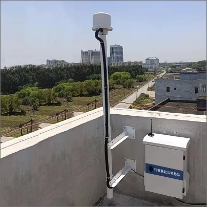
Geospatial Infrastructure
The foundational hardware for regional CORS networks, providing High-Precision correction services for Surveying and Mapping.
-

High-Precision Monitoring
NET20Plus Delivers the Sub-Centimeter accuracy required for deformation monitoring of Bridges, Dams, and Critical Infrastructure.
-

Industrial Automation
Provide Cm-Level positioning reference for Coordination, Agriculture Navigation and other Industrial Automation.
-

Scientific Research
Supports specialized applications in Meteorology and Atmospheric Research through its dedicated event and 1PPS Interfaces.
Get in touch.
Click the button to reach out, fast response within 24 hours!