Versatile Lidar Scanner
EASY-TO-SCAN
Learn more about our newest
Detection 3D Lidar Scanner!

Main Features
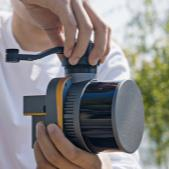
High efficiency
Ultra light aerial survey module,image acquisition not limited by LiDAR measurement range,filght height can be appropriately increased to improve the operation efficiency

No signal limitation
Switch to SLAM mobile scanning mode, no limitation of GNSS signal,indoor and ourdoor data integrated collection makes the 3D data more complete.

Not affected by light
LiDAR is not affected by environment, less sideoverlap,wider coverageof single flight, data can be easily collected even inthe night.

Real-time monitoring
Stimultaneous acquisition of point cloud and orthophoto toachieve the real-time monitoring of flight trajectory,3D point cloud and images during the whole flight of the system.
Application Scenarios

REAL 3D

WATER CONSERVANCY & HYDROLOGY

SMART MINING

EMERGENCY RESCUE
Get in touch.
Click the button to reach out, fast response within 24 hours!